 Save Bennachie
twitter.com/savebennachie
facebook.com/Save-Bennachie
www.savebennachie.com
Latest Update for Alliance Members
The Community Council Forums will allow you to find out more about the design and assessment process to be followed as the scheme progresses, as well as giving you the opportunity to provide vital feedback. These Forums will be hosted by Transport Scotland’s A96 Dualling team and our design consultant AmeyArup.
The South Community Council Forum which will take place on Thursday 7 December between 14.00 and 16.00 hours in the Small Hall at Inverurie Town Hall, Market Place, Inverurie, AB51 3SN.
Responses can be made by post utilising the contact information below, or by emailing our Stakeholder Coordinator, Bonny Pailing, at bonny.pailing@arup.com.
Postal Address: AmeyArup Office 7, Thainstone Business Centre, Thainstone, Inverurie, AB51 5TB
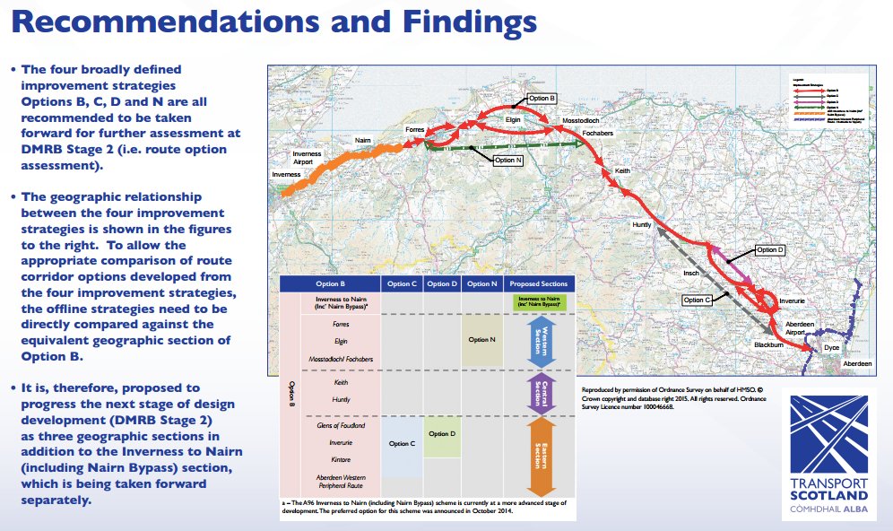
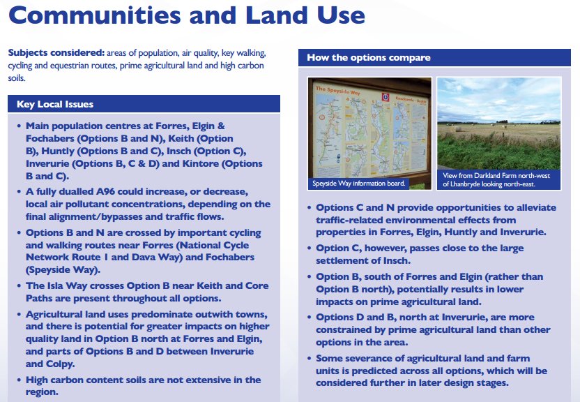
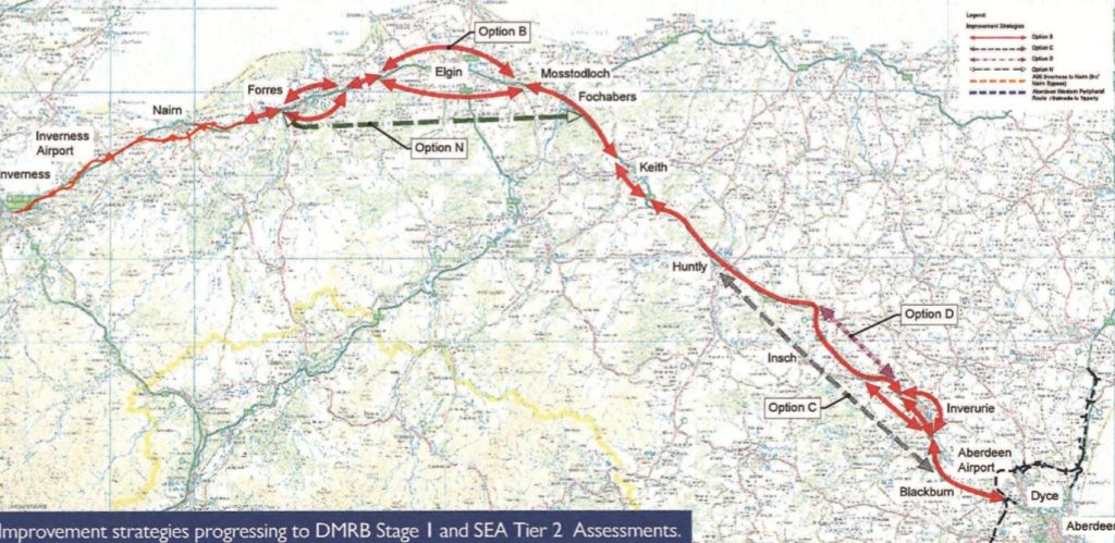
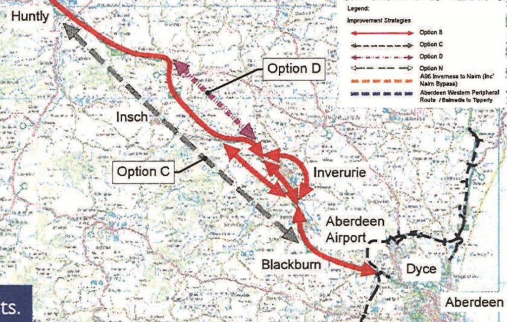
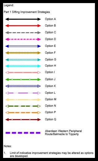
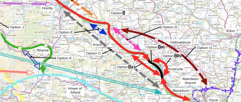
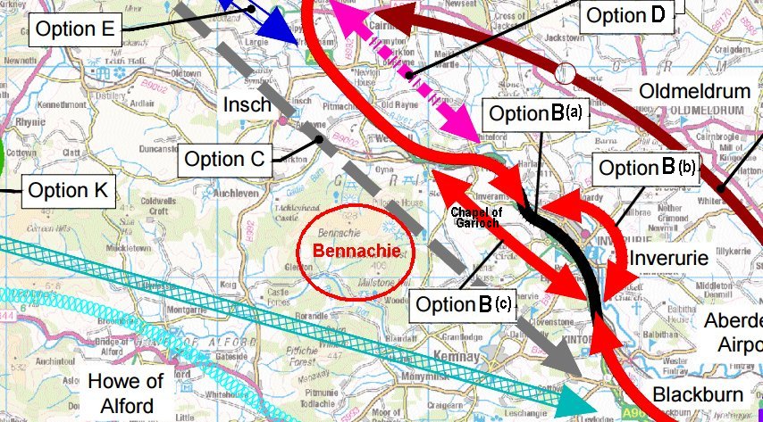
As one of the Save Bennachie Alliance members, your organisation will be aware that the A96 Inverness-Aberdeen road will be upgraded/re-routed to dual carriageway status by 2030. Two of the route options under consideration around Inverurie will impact Bennachie and its surrounding areas. Please refer to the attached map to see the current route options being considered for the eastern section.
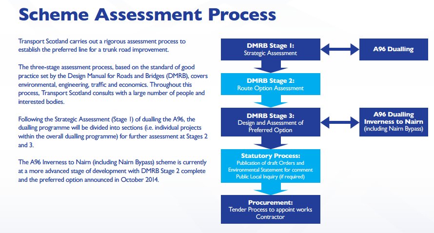
Design consultants Amey Arup were appointed in July this year for a 2 year, £33 million contract covering the design and delivery of the Eastern Section-Huntly-Aberdeen. Amey Arup will come up with their preferred route options within 2 years of the contract award. The final decision on the actual route will be made by the Cabinet Secretary for Economy Jobs and Fair Work, and the Minister for Transport.
Amey Arup have held their first public consultation “Meet the Team” earlier this month in Inverurie, Huntly and Blackburn. These events were well attended. They will now consult stakeholders such as local community councils, Aberdeenshire Council, national organisations.
Through the Save Bennachie Alliance, over 1000 individual members have joined forces with local and national organisations including the Bailies of Bennachie, Oyne Community Association, Kemnay, Kintore , Cluny, Midmar and Monymusk Community Councils, Mountaineering Scotland , North East Mountain Trust, Cosmic Hillbashers, Cairngorm Club, Ramblers Scotland, Woodland Trust, Inverurie Business Association, and Aberdeenshire Environmental Forum. Save Bennachie facebook has over 2,500 followers and our website has had 32,813 page views since January, with 23,919 sessions of which 81.04% are new sessions.
Whilst the Save Bennachie Campaign is a strictly non-political cause, we do have cross party support. North East MSPs Bill Bowman, Alexander Burnett, Peter Chapman, Liam Kerr, Lewis Macdonald, Jenny Marra, Gillian Martin, Tom Mason and Mike Rumbles, the MP for Gordon Colin Clark and Lord Bruce of Bennachie all came together to publish a joint statement “that it would be completely inappropriate and unacceptable to site the new dual carriageway anywhere likely to impact adversely on the integrity of Bennachie and its surrounding area”.
MSPs Lewis Macdonald and Mike Rumbles have written letters to the Cabinet Secretary for Economy, Jobs and Fair Work. Stewart Stevenson MSP has asked a question in the Scottish Parliament about the concerns in relation to Bennachie at First Minister’s Question Time.
150,000 visitors come to Bennachie annually for recreational purposes. With recently awarded Special Landscape Area status, an unspoiled Bennachie is a valuable and massively used resource in terms of physical and mental health, education and tourism. As the oil and gas industry declines, so the importance of tourism to the area will increase, bringing many economic benefits to the local economy. It is therefore increasingly important to protect and preserve Bennachie.
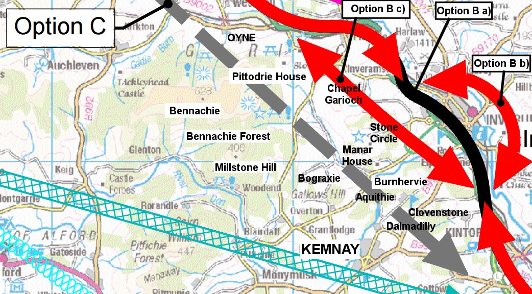
Routes crossing the foothills of Bennachie would be at a high level, with safety and winter resilience issues. These routes would be at a distance from centres of industry and population, so would have a negative impact on economic growth, and offer no opportunity of promoting an integrated transport network and the use of public transport. Route C, over 15 miles long, which would impact Bennachie most severely, would have to be built in its entirety at huge public cost.
The Save Bennachie Campaign firmly believes that siting the dual carriageway to the east of Inverurie would create significant opportunities for the whole area. As per calls from Aberdeenshire Council Infrastructure Services Committee, Transport Scotland has a rare opportunity, through joined up thinking with Aberdeenshire Council, to implement the most cost effective solution for both the A96 and A947 projects.
Each working day, 63% of traffic approaching Inverurie on the A96 from the south turns off at the two roundabouts entering Inverurie, causing major traffic congestion and safety concerns in the town. Any route to the west of Inverurie is a missed opportunity to alleviate this major problem.
We are calling on the Minister for Transport and Cabinet Secretary for the Economy, Jobs and Fair Work to rule out the route options which would impact Bennachie at the earliest opportunity.
The coming months will be critical for the future of Bennachie as we have come to know it. Please continue to support our campaign by engaging with Amey Arup and Transport Scotland at the address below and by asking your members to write as individuals.
Contact details for communicating with Amey Arup –
Stakeholder co-ordinator Bonny Pailing Tel 01467 672500
e-mail: bonny.pailing@arup.com or
Landowner & Communities Manager Billy Gordon Tel 01467 672500
e-mail: billy.gordon@amey.co.uk
By post: AmeyArup, Office 7, Thainstone Business Centre, Thainstone, Inverurie AB51 5TB
Contact details for communicating with Transport Scotland
e-mail: a96dualling@transport.gov.scot
By post: A96 Dualling Team, Transport Scotland, Buchanan House, 58 Port Dundas Road, Glasgow
G4 0HF
Read The Latest Newsletter
Bennachie Designated Special Landscape Area Status
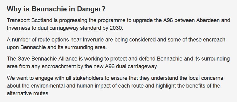
Save Bennachie Alliance is working to protect and defend Bennachie and its surrounding area from the A96 dual carriageway.
Vote Now To Protect Bennachie, 13 May 2016 DEADLINE
Extract from DMRB S1. Assessment Rep. Transport Scotland May 2015
Option B (a) Inverurie Bypass (Inner)
The Inverurie Bypass (Inner) strategy comprises the existing A96 corridor Old Rayne to Kintore including the existing Inverurie Bypass. The A96 in this section is a single carriageway cross section between Old Rayne and Port Elphinstone Roundabout south of Inverurie where the A96 continues as dual carriageway. At Pitcaple, to the north-west of Inverurie, the existing single carriageway is constrained by the Aberdeen to Inverness Railway Line, which runs parallel to the A96, as well as roadside developments and the River Urie. At Inveramsay, the railway crosses over the A96 on a masonry arch bridge which has a 4.4m height restriction and the traffic under the structure is restricted to a single lane controlled by traffic signals, due to the arch and span of the bridge. The replacement of this structure is currently planned under the A96 Inveramsay Bridge Improvement project (refer to Section 1.7). The proposed bridge and road realignment is a single carriageway scheme.
The existing Inverurie Bypass is constrained along the north-east boundary by the residential and commercial properties of Inverurie and Port Elphinstone. In addition, the south-west boundary of the A96 is constrained with residential developments and a golf club at Inverurie. An existing local road overbridge crosses over the Inverurie Bypass on a three span structure which constrains the road cross section due to the leaf piers adjacent to the road.
The A96 crosses the River Don and its floodplain on a 140m long 4-span bridge. The primary junctions along the single carriageway include the B9002 and B9170. In addition, the dual carriageway section of the A96 includes two at-grade roundabouts with the B993 and a local road at Thainstone as well as two left in/left out simple T-junction at Clovenstone and Kintore Business Park. In addition, to these junctions, the existing dual carriageway section contains a left in/left out direct access and a left in/left out field access, both of which are located between the Port Elphinstone Roundabout south of Inverurie and Thainstone Roundabout.
Option B (b) Inverurie Bypass (North)
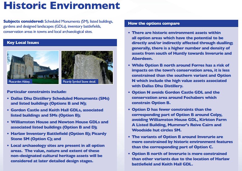
The strategy for the proposed bypass to the north of Inverurie crosses the River Urie and the River Don and their associated floodplains as well as the Aberdeen to Inverness Railway Line. In addition to the floodplains, the environmental constraints to the north of Inverurie include a scheduled monument (a Roman temporary camp) at Durno to the northwest of Inverurie, Harlaw Battlefield to the north of Inverurie as well as Keith Hall Designed Landscape to the east. The primary roads to the north of Inverurie are the B9001, B9170 and B993.
Option B (c) Inverurie Bypass (South)
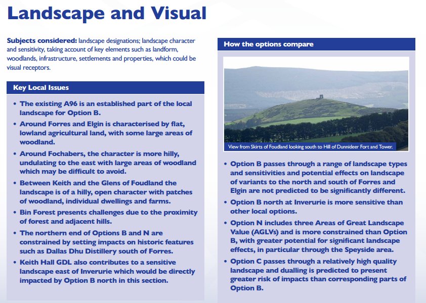
The southern strategy at Inverurie would also cross the River Don and its floodplain, albeit the floodplain is narrower in this section of the river compared to the northern strategy. The topography to the south of Inverurie is undulating with numerous hills and valleys as the land starts to rise towards to Bennachie Mountains to the west of Inverurie. The southern strategy would likely cross the Aberdeen to Inverness Railway Line near the north-western extent of the strategy. In addition, two SSE high voltage overhead transmission lines run approximately parallel in a north-west to south-east direction. The primary roads to the south of Inverurie are the B9002 and B993.
Option C Offline from Huntly to Blackburn
This option was developed, irrespective of any constraints, to provide a more direct line from Huntly to Blackburn, bypass Inverurie to the south and avoid a number of sections of poor road alignment on the existing A96. The option would likely tie-into the existing A96 between Huntly and the Glens of Foudland at the northern extent and between Blackburn and Kintore on the existing dual carriageway at the southern extent of the strategy.
The topography is the primary constraint for this strategy due to the undulating topography with high spots at Winds Eye (314mAOD), Wishach Hill (419mAOD) and the Hill of Foudland (467mAOD). The Bennachie Mountains (528mAOD) are located to the west of Inverurie. The strategy would likely have to pass in the gap between Wishach Hill and the Hill of Foudland. In addition, the strategy would require structures to cross the River Don, River Bogie, and a number of smaller watercourses as well as the Aberdeen to Inverness Railway Line near Insch.
Option D: offline alternative to the Option B strategy
Option D is a fully offline alternative to the Option B strategy between the Glens of Foudland and Pitcaple. This strategy could be delivered in combination with either the Inverurie Bypass (Inner) or Inverurie Bypass (Northern) Option B strategies. Depending on which strategy Option D is combined with, a bridge may be required to cross the River Urie. Two SSE high voltage overhead transmission lines run through the area in an approximately north to south direction and a north-west to south-east direction. Environmental constraints within this section include two GDL designations at Williamston House and Newton House as well as a scheduled monument (a Roman temporary camp) at Durno. The main local roads within this corridor are the A920 and B992.
